The eastern half of Nebraska is very much like IL & IA,. Green with rolling hills and farms. But as we moved west, the state becomes flatter, and more barren. As the elevation begins to get higher, the vegetation thins out and becomes scrubby. The trees are mostly evergreens. We followed the Platte River for miles. Along the river on both sides of the highway, were small manmade ponds of various sizes. I wondered if they were from strip mining or quarrying (sand and gravel are plentiful out here) Vince thought they might have been the result of building the highway. Lots of people fishing in them.
It was another beautiful day, and the temp got up into the high 70’s. Nebraska is an extremely long state. It seemed we’d never get to the end of it. As the elevation rose, we drove through the high plains. We saw thousands of head of black angus, many of which were in feed lots getting fattened up for market.
Just west of North Platte, NE, we entered the Mountain Time Zone. No mountains in sight yet though.
Along the way we saw a huge wind farm with perhaps a hundred wind turbines. Many of the exits off of the highway were simply to unpaved roads. The ramps were paved, and once at road level, the paving ended, and the road often went off into nowhere.
Finally out of Nebraska and into Wyoming. We keep going up into the high desert. Here there are no trees at all. Sandy soil and scrub. The cattle are free ranging. No neat pens, and not much in the way of civilization is visible. I saw a herd of pronghorn antelope which spread out over a couple of miles. Jeff said it may have been more than one herd, since I probably saw more that a hundred and they don’t usually travel in herds that large. The weather forecast is for rain & snow tonight and tomorrow, so we will push on west. Had planned to stop in Laramie; but it was too early to stop, and in view of the forecast, we opted to push on to Rock Springs, another 188 miles. We drove through a little rain a snow showers going across the high plains, but not enough to slow us down. So we were pretty tired by the time we got there.
May 1,Day 3 We woke up with our internal clocks still on Central time in Rock Springs, WY and we were on the road by 8:15 MT heading toward SLC, UT.
We are traveling through the high desert. It’s pretty barren lots of scrub, but no trees. The soil seems to be very sandy, and about all that can live out here are grazing animals and their predators. This is Wyoming cattle country.
An hour into the drive _ Ft. Bridger – we see lots of snow capped peaks to the south and west of us. The hills around us are layers of limestone topped with sandstone. All badly eroded into interesting shapes.
Near Ft Bridger is a large Wind Farm. A long line of wind turbines high on a ridge, positioned to add electric power into the grid.
We are also suddenly back below the tree line. Scrubby dwarf evergreens dot the hillsides, and a few deciduous trees show up too. We also ran into some snow west of Ft. Bridger.
We have encountered mostly truck traffic all on the way since leaving Omaha. It’s not really tourist season yet, so not many 4 wheelers along this route. We’ve also seen many signs along the highway saying that if the lights on the sign are flashing, that traffic should get off the highway at the next exit. I don’t think I’d want to get caught out here if the highway was closed due to snow. There is NOTHING out here! Not even many rest areas.
Suddenly, we crest a ridge and begin the descent into Salt Lake City. The road has between 3% and 6% grades and S curves all the way down speed limits 75mph. A few white knuckle curves, and we’re down.
The weather today has been cold, and trying very hard to rain and/or snow and visibility is
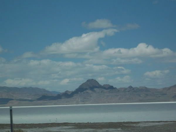 poor, so we decided not to go to Salt Lake Park, but kept on driving. As we drove west along the south end of the Great Salt Lake, we were able to find a parking area where we could stop and take pictures of the lake. Later this afternoon we also found a rest area where we could walk out onto the Great Salt Lake desert. It was incredible to actually find myself walking on rock hard salt! The desert is white, and is made up of mostly salt with a little sand mixed in. The only place that anything grows is where the DOT brought in dirt for the rest area, and for the roadbed. And even there the vegetation is scrubby and brown.
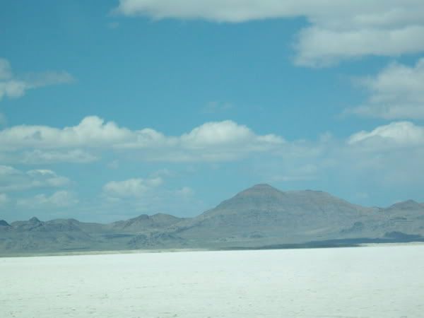
After passing the desert, we again drove up into higher elevations and then we spent most of the rest of the day above the tree line. Utah is a very narrow state, E/W so shortly we entered Nevada. Throughout NE, WY, UT and now in NV, towns are very sparse, so we’ve had to be a bit careful about planning our gas and motel stops. We did stop at a small town in NV to shop for lunch food so we could avoid having to stop and buy a meal. Our cooler lunches have been a good idea. They keep us moving, and mean we only buy one meal a day in restaurants.
Tonight we made it to Lovelock, NV and found a mom & pop motel to stay in. I’ve called ahead to Carson City to arrange a room with an Evergreen club member, so tomorrow night will cost us $15, and include breakfast. From here to there is about 115 miles, and we will be able to ride on the Virginia & Truckee RR in Saturday noon. Then it’s only about 100 miles to Jeff’s.
Jeff has called us on Tuesday and Wednesday nights; and Kurt called tonight. They are both anxious to know when we will arrive.
No comments:
Post a Comment